A walk up Taupiri Mountain
Walking to the summit of Taupiri Mountain on the shortest day seemed a fine idea. We’ve driven past too many times to count, but had never got around to climbing the sacred maunga.
Finding the way to the track took a bit of research. Accounts varied and were short on detail – for directions, see the end of the story.
Upon parking we were immediately greeted by a swarm of friendly kitties who clearly hoped for a bit of salmon.
The start of the track. Straight up from here!
This little nest of fungi was enjoying the damp, midwinter weather.
A nice grove of nikau palms overhangs the track.
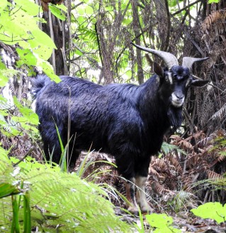
This goat was curious as to what we were about.
The summit! Sadly, it was under cloud but there were moments when the surrounding countryside was visible.
A nicely coloured kohekohe, with rata vine, on the way down.
A nice view of Taupiri farmland.
The gateway at the far end of the track.
That’s all folks! The cats say come back when the cloud is gone for a truly stunning view. We shall.
How to get there
UPDATE: Roading works in 2020 have changed the access to the track, and much for the better. The end of the old gravelled track off State Highway 1 has been blocked and there is now a one-lane bridge over the Mangawara Stream, running off the end of Watts Grove. This short No Exit road is the first on the left off Orini Rd, coming from the Gordonton Rd end. Park on the far side of the bridge (which isn’t on the map below, it’s too new!).
The walking track runs off the gravelled track which runs around the base of the mountain. The first entrance to the walking track is visible a short distance up the hill, marked by the wooden arched gateway – you can just make it out in the photo above.
The track itself is steep and slippery in wet weather. Good shoes are a must. Total time to walk the loop is about one and a half to two hours.


Pingback: Sharnay Waikato’s top young volunteer - Number 8 Network
Thank you very much for great photos, instructions to get to the track and a well defined map, appreciated.
Pingback: View from Taupiri Mountain - Number 8 Network
Your map was very useful to find the entrance to parking for this walk. Unlike yourself we went yesterday and it was beautifully fine with incredible views from the top. However I feel the need to advise walkers that the track has deteriorated to being nearly completely over grown especially on the way down. Many trees have fallen across the track so there is some scrambling over and under to be undertaken. I would recommend that people have proper footwear and be of advanced fitness and agility, certainly not one for small children – very Bear Grylls!
Thanks for your comment Erica – sad to hear the track has deteriorated to such an extent. Hopefully this will change in the near future. In the meantime, nearby Pukemokemoke is a splendid walk. Have you tried that?
Yesterday I did this track with my son and four grandchildren 7-17 years. We walked up the far side of the track first as it was less steep and thoroughly enjoyed the whole experience. The track was in good condition, although beneath the summit a collection of young nikaus will obstruct the way in years to come. Thanks for the great description and map on this site, found by chance.
Very helpful and accurate, especially the map. Thank you!
Most welcome Simon!